
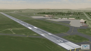
MVRsimulation has built 28 virtual U.S. airports and airfields of interest to our customers, for rendering in Virtual Reality Scene Generator (VRSG). These airports and airfields are available on MVRsimulation's round-earth 3D terrain of Continental US plus Alaska and Hawaii (CONUS++).
All the CONUS++ virtual airports and airfields have 1 meter per-pixel (mpp) or better resolution. Most airfields have higher resolution insets, built with imagery ranging from 0.15 mpp to 0.60 mpp, blended with the underlying CONUS++ 1 mpp terrain imagery. Elevation sources range from DTED 1 to 30 meters-per-post (mpp) to 10 mpp blended for seamless transition to custom elevation that matches FAA airfield elevations with at least 95% accuracy.
All airports/airfields were built with MVRsimulation Terrain Tools for Esri® ArcGIS® in MVRsimulation’s round-earth terrain format. Culture content was placed in Scenario Editor. All cultural models, geospecific and geotypical, are geolocated on the terrain. All culture models are available in MVRsimulation's 3D model libraries.
Many of the virtual airfields were built at the request of customers. In most cases, a combination of geotypical airfield models from MVRsimulation’s extensive culture model libraries were used and a site-specific control tower was built (based on publicly available photos). All contain accurate runways and runway lights, markings, and signs. Culture on some airfields are geospecific, that is, based on photos of the buildings and other structures on the airfield. Having such photos makes it possible to create geospecific models of hangars, terminals, control towers, and other structures for a given airfield.
MVRsimulation updates its 3D terrain on an ongoing basis as new source data become available or upon a customer's order to have a new airport or airfield built.
")
")
")
")

")
")
")
")
")
")
")
")
")
")
")
")
")
")
")
")
")
")
")
")
")
")
")