
Terrain Tools for ArcGIS
MVRsimulation Terrain Tools for ArcGIS® Pro enables users to turn their geospatial data into real-time 3D terrain to render in Virtual Reality Scene Generator (VRSG) from within their GIS software. Building on the industry standard ArcGIS Pro platform, MVRsimulation's Terrain Tools extension combines powerful 3D terrain building functionality with an accessible and intuitive interface that can be easily understood by anyone with a comprehension of geospatial data concepts and some experience with ArcGIS Pro.
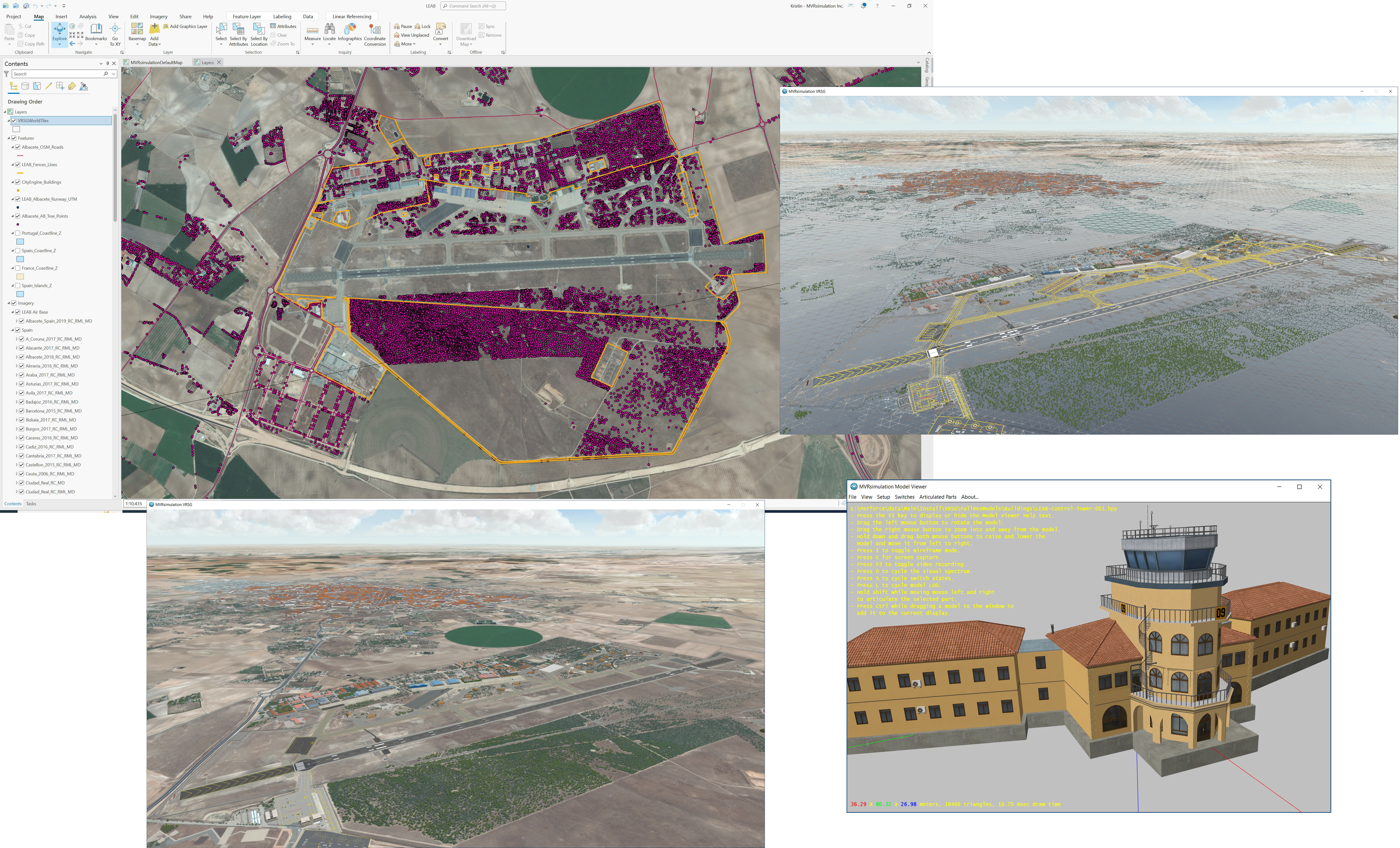
Above on the left: MVRsimulation’s Terrain Tools for ArcGIS Pro with a map of LEAB Airport in Albacete, Spain. Other scenes are rendered in MVRsimulation VRSG of the cultural wireframe and resulting geospecific 3D terrain of the airfield including a geospecific control tower as shown in Model Viewer.
Terrain Tools enables MVRsimulation to focus on the terrain composition while taking advantage of the significant GIS functionality provided by Esri products. Terrain Tools complements MVRsimulation's image generator, VRSG.
CORE FEATURES
In addition to creating real-time terrain in MVRsimulation's round-earth terrain format for rendering in VRSG, the key features of MVRsimulation Terrain Tools for ArcGIS Pro include:
- Live compositing display of raster imagery and elevation data in a WYSIWYG interface.
- Support for any format of source data supported by ArcGIS.
- Raster display capabilities such as pan-sharpening, custom band order, multiple re-sampling techniques, histogram stretching, contrast and brightness control, masking, and edge blending.
- Ability to supply vector data to define linear and areal features. Generate road networks, fine tune elevation with polygon or point data, create extruded buildings, walls and fences, create large coverage areas of cultural lights, or specify cut-in areas with blended geotypical ground textures.
- Support for building underwater geometry (bathymetry) to increase the terrain fidelity of the ocean floor for use in littoral scenarios with VRSG’s 3D ocean sea states.
- Ability to compile 3D and 2D external terrain geometry (such as inset models and runways) directly into the terrain for a seamless integration between the terrain and cut-in model geometry.
- Ability to compile buildings from 2D polygon footprint features using an ArcGIS® CityEngine® rule package.
- Terrain feature definition user interface that eliminates the need to edit feature definition tables directly.
- Distributed build system, which allows asynchronous build processes across multiple machines on a local network to collaborate in building a set of tiles. The build can be monitored and administered from any machine on the local network using a dynamic browser-based user interface.
- Renders in VRSG with external 3D content built upstream as part of the art pipeline. External 3D content includes areas of culture created with VRSG Scenario Editor or with ArcGIS® CityEngine®. (In the latter case, models exported in FBX format can be converted to MVRsimulation's model format.)
- Support for the Navy's Portable Source Initiative (N-PSI) standard for terrain database source data.
All features integrate seamlessly with the industry’s leading GIS platform. Click here to see the features of the latest version of Terrain Tools.
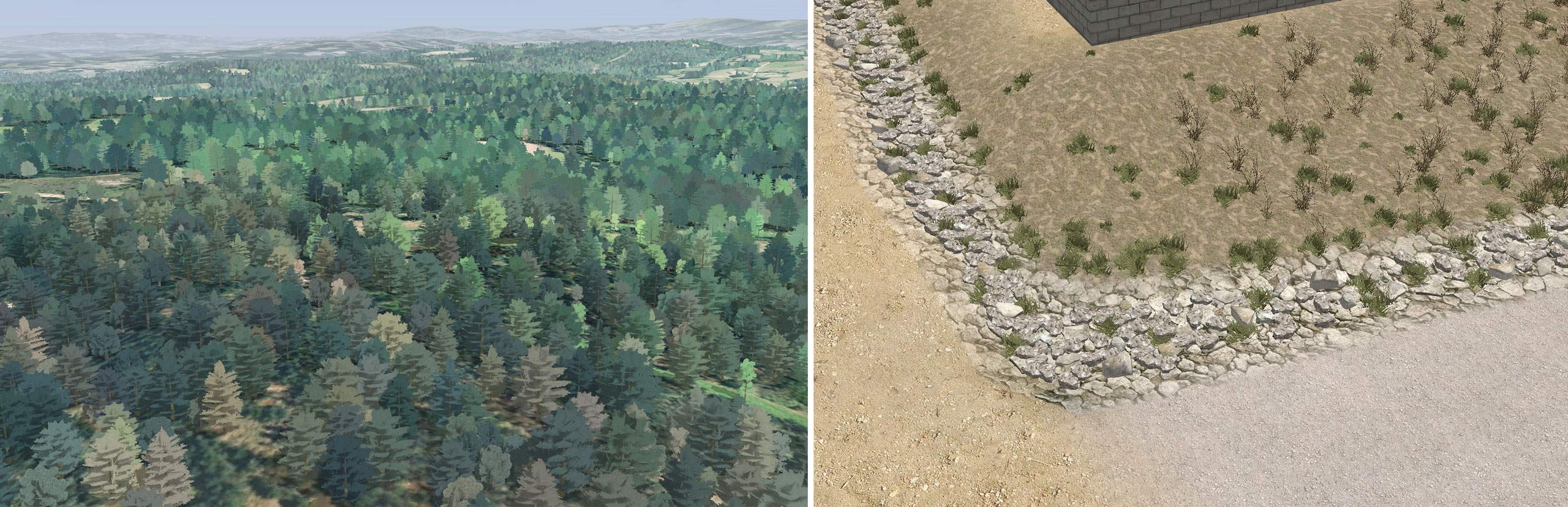
MVRsimulation VRSG scenes of resulting terrain of Terrain Tools' ability to generate dense tree coverage, and ability to blend multiple adjacent microtextures.
VRSG TERRAIN FORMAT
MVRsimulation's round-earth terrain format is ideal for aerial and air-to-ground training applications, which require vast areas of terrain fidelity both in the air and at ground-level. Terrain Tools is currently used to build terrain for many manned and unmanned aircraft simulators and for joint fires and JTAC simulation training. The VRSG round-earth terrain format has many benefits; most importantly, the terrain models the earth to a high degree of accuracy over its entire surface. This level of accuracy is vital for targeting applications and determining intervisibility.
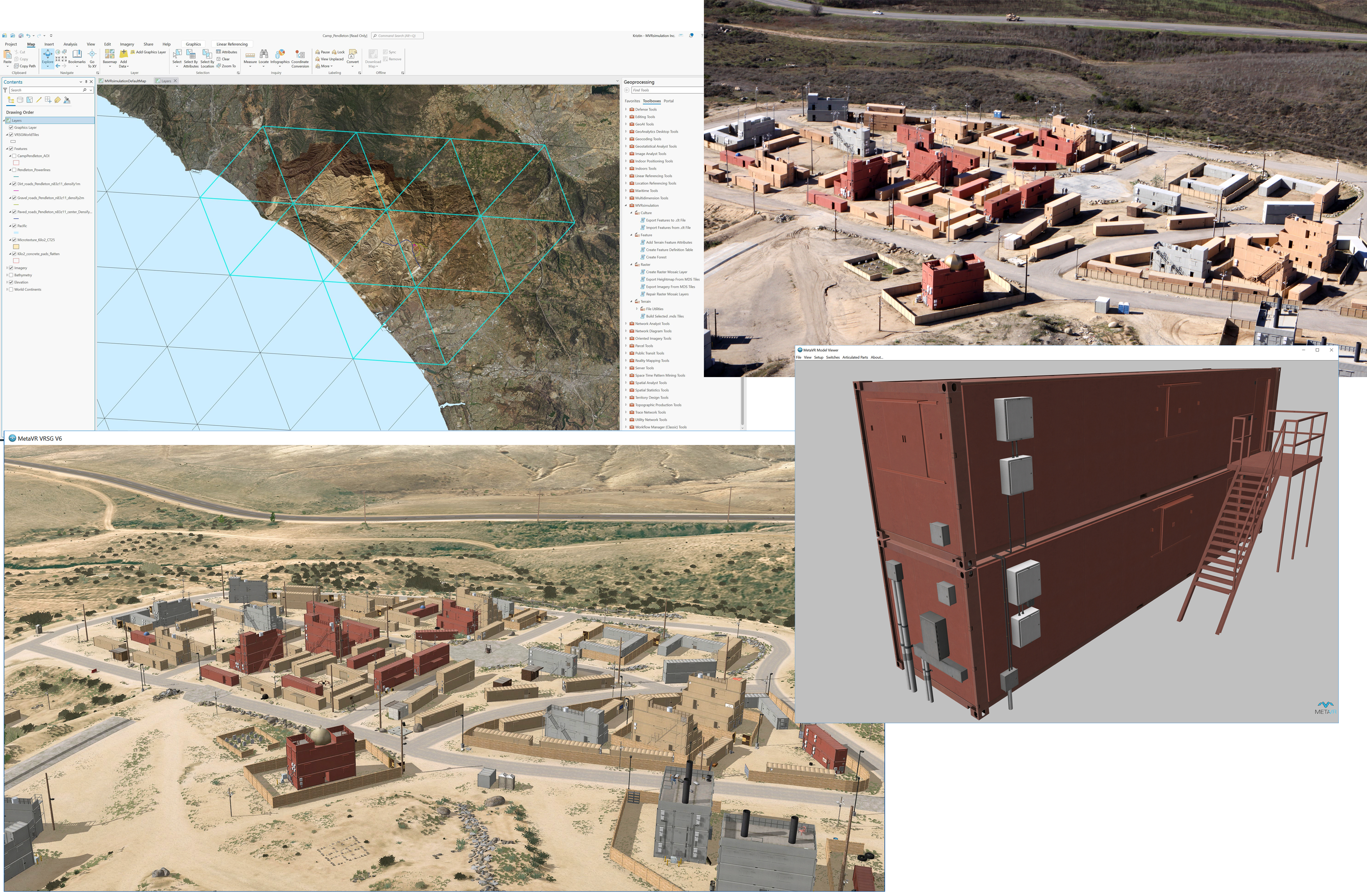
Terrain Tools map view in ArcGIS Pro of MVRsimulation’s virtual replica of the Kilo 2 MOUT site at Camp Pendleton, and the resulting real-time textured tiles in MVRsimulation's VRSG. Real-world image of the MOUT site. Photo (upper right): USMC The 3D geospecific and geolocated models were built externally in Luxology Modo and Autodesk 3ds Max. (One is displayed in Model Viewer.) Models were then placed on the terrain with Scenario Editor as part of the terrain workflow.
Another critical advantage of the VRSG terrain format is its segmented database representation. Terrain built in VRSG terrain format is comprised of relatively small, self-contained terrain tiles that fit together seamlessly but can be built separately. This property enables a high degree of parallel processing of terrain since many different machines licensed for ArcGIS and Terrain Tools can build tiles for a given area at the same time.
Within the ArcGIS interface, coastlines and road networks can be digitized and cut out from geospecific imagery using Terrain Tools. At runtime, VRSG generates simulated 3D ocean in the regions identified as water, and blends road textures with underlying imagery. The terrain tiles seamlessly match complete water tiles generated by VRSG.
MVRsimulation VRSG real-time 3D littoral view of virtual Costa Verde, Spain, simulating the ocean wave fall-off and transparency at the shoreline.
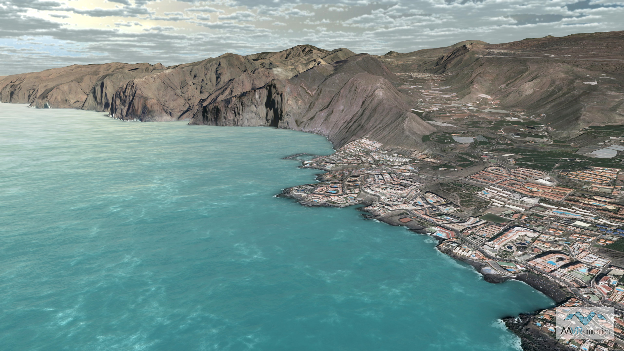
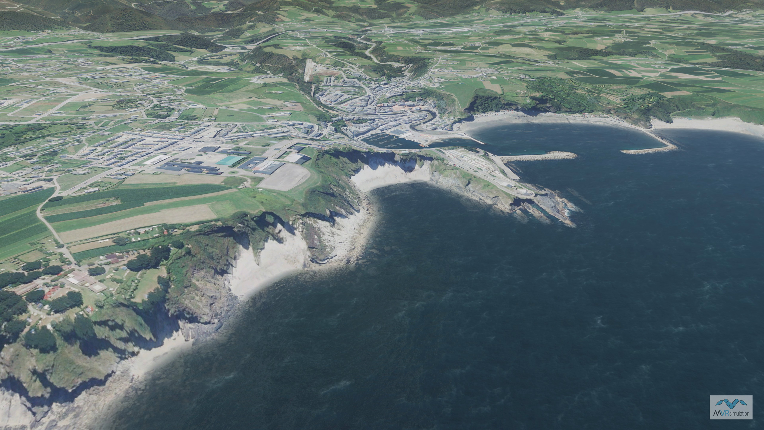
MVRsimulation real-time scene of high-resolution, geospecific 3D terrain of Tenerife, Canary Islands, Spain, with a bathymetric shoreline for supporting VRSG's 3D ocean simulation.
In the example above, MVRsimulation Terrain Tools was used to create the terrain mesh of the high-resolution representation of the shoreline off the coast of Spain's Costa Verde and Tenerife, Canary Islands. The bathymetry data enhances the fidelity of where the shoreline meets the 3D ocean generated by VRSG at runtime.
REQUIREMENTS
MVRsimulation Terrain Tools requires a minimum of a Standard license level of ArcGIS Pro 3.1.3 for preparing raster data. Additional terrain-building machines can use any license level (Basic, Standard, or Advanced) of ArcGIS Pro version 3.1.3 and above. ArcGIS Pro can be purchased directly from Esri.
Terrain generated with Terrain Tools can be visualized in any version of VRSG. The latest version of VRSG is recommended to visualize terrain built with the latest features of Terrain Tools. System requirements include Microsoft Windows 10 64-bit operating system or later and 16 MB RAM.
MVRsimulation is a member of the Esri Partner Network.
You can request a quote for MVRsimulation Terrain Tools for ArcGIS directly from MVRsimulation by consulting the Price List and then filling out the quote request form.